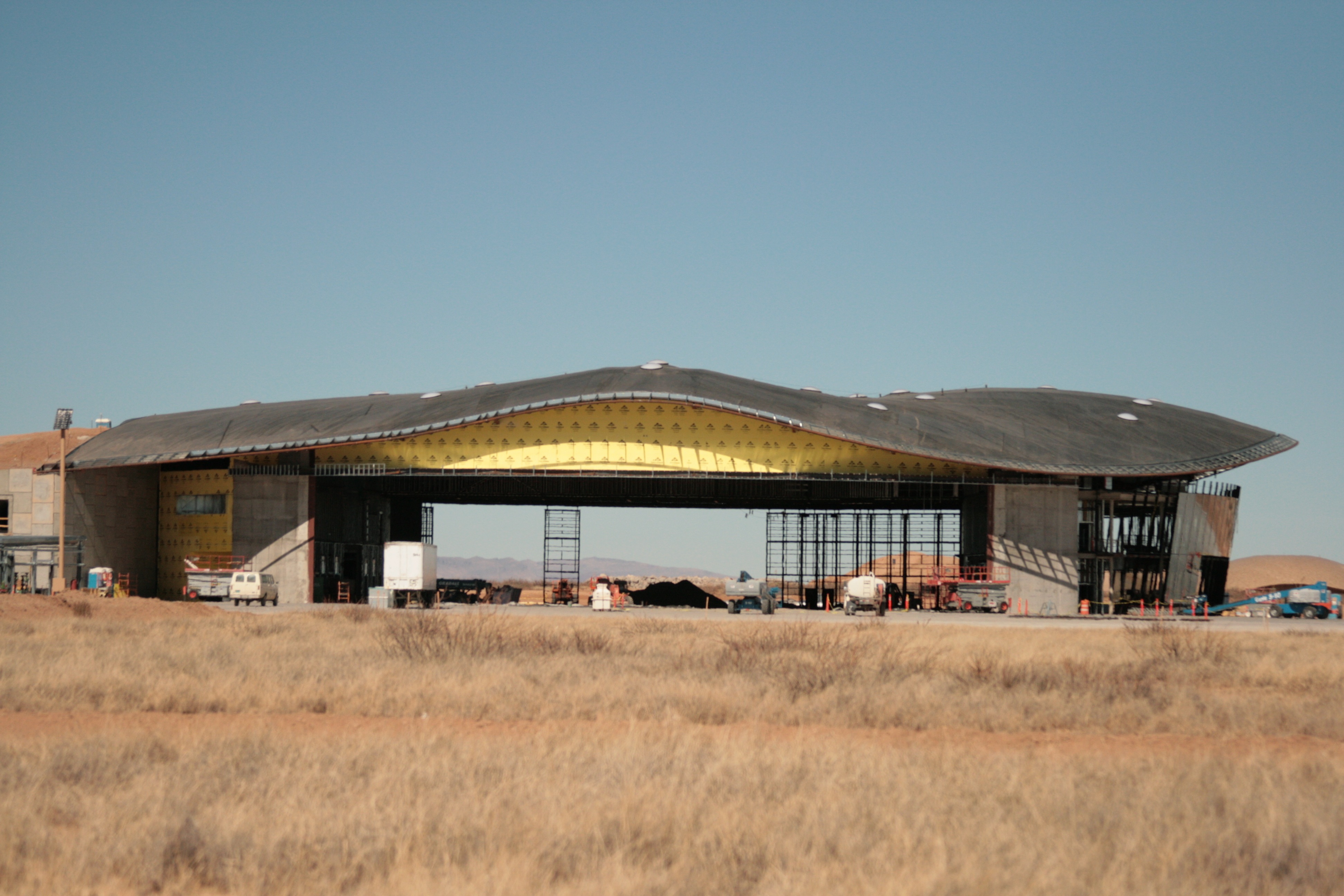
From Nature Made to Man Made

Going to jump tracks a bit from yesterday’s purple mountains majesty to marvels of human engineering.

A couple days after my return from New Mexico, I had to drive up to Sacramento for work stuff.

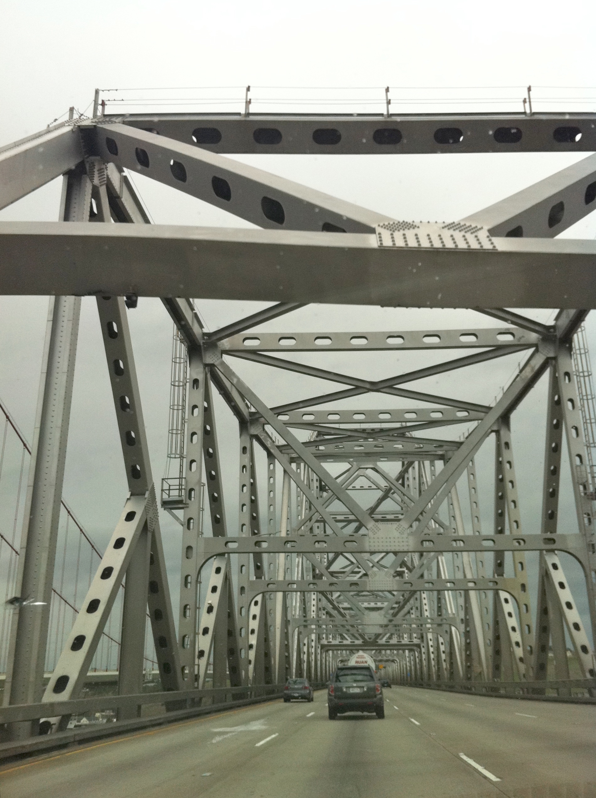
On the journey over highway 80, there are two major bridges to cross, the Bay Bridge, and the Carquinez Bridge.

Both are, in my mind, very Jekyll and Hyde. Both beautiful and ugly at the same time.

When riding over these bridges, I always have to wonder what the bridge builders around here have got against the east side of a perfectly nice bridge?

Here, let me show you.

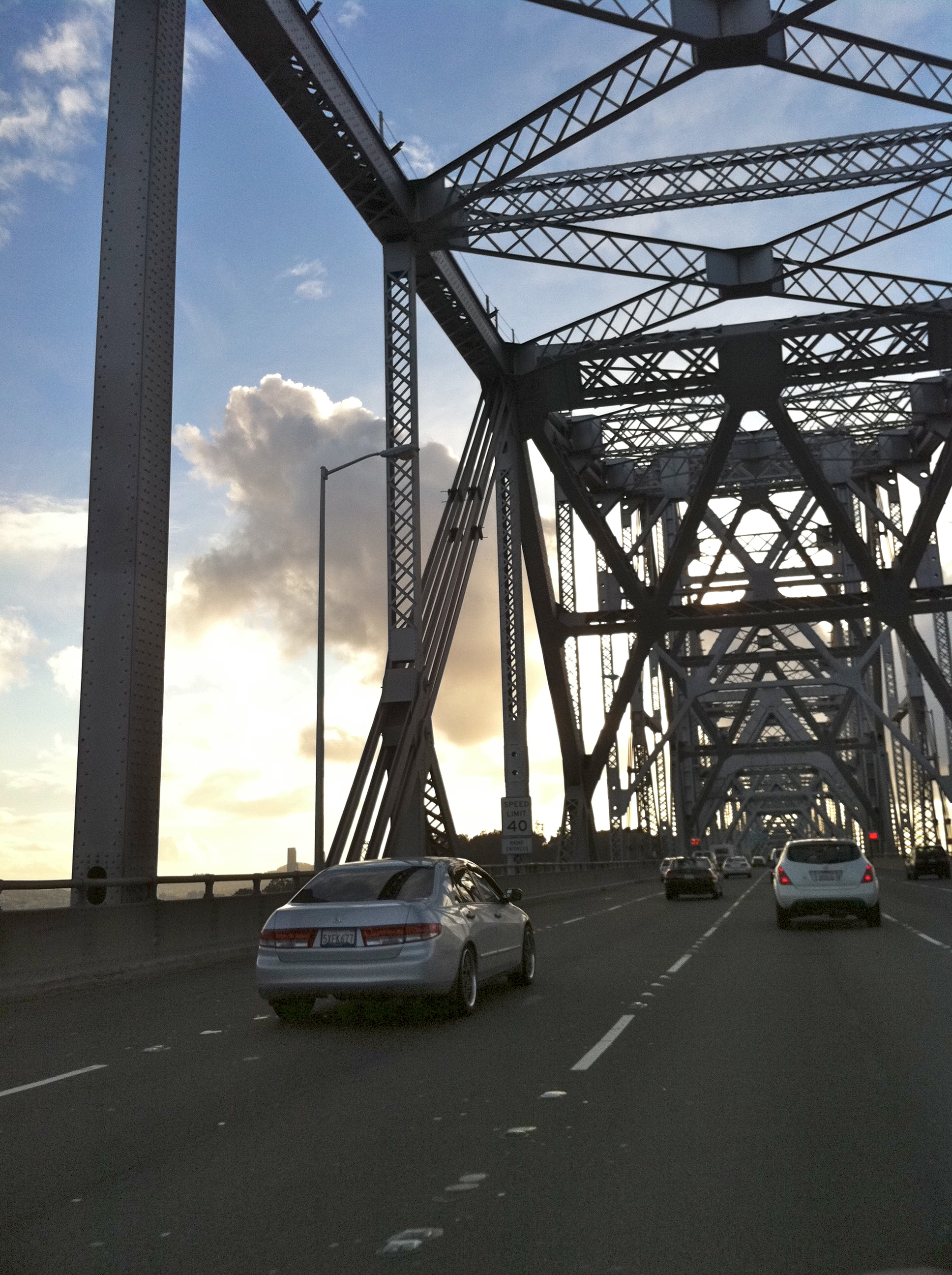
This is the eastbound section of the Carquinez, headed toward Sacramento:


It’s got sort of an Erector Set toy feel about it, no? (assuming you are old enough to remember Erector Sets)

It’s very utilitarian and functional and not very aesthetically pleasing.

And then, for comparison, here’s the westbound section of the same bridge (headed toward San Francisco).


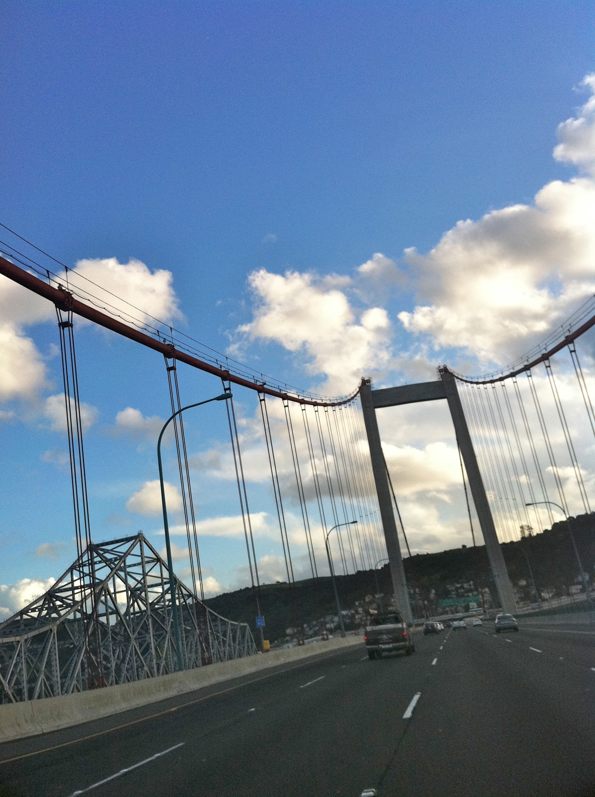
Lovely! Clean lines and very modern and stylish.

You can even see the less attractive side of the bridge off to the left.

I’d like to think that this two opposite halves approach is an anomaly to only the Carquinez, but no.

Let’s talk the Bay Bridge. It’s split into two sections, the eastern span (east of Treasure Island) and the Western Span (west of Treasure Island).

These photos are from the top deck, headed west, but look at the vast difference in the two halves of the bridge.

Eastern span:


Again with the construction by Erector Set! So not pretty. Utilitarian.

And then the elegant, iconic western span:


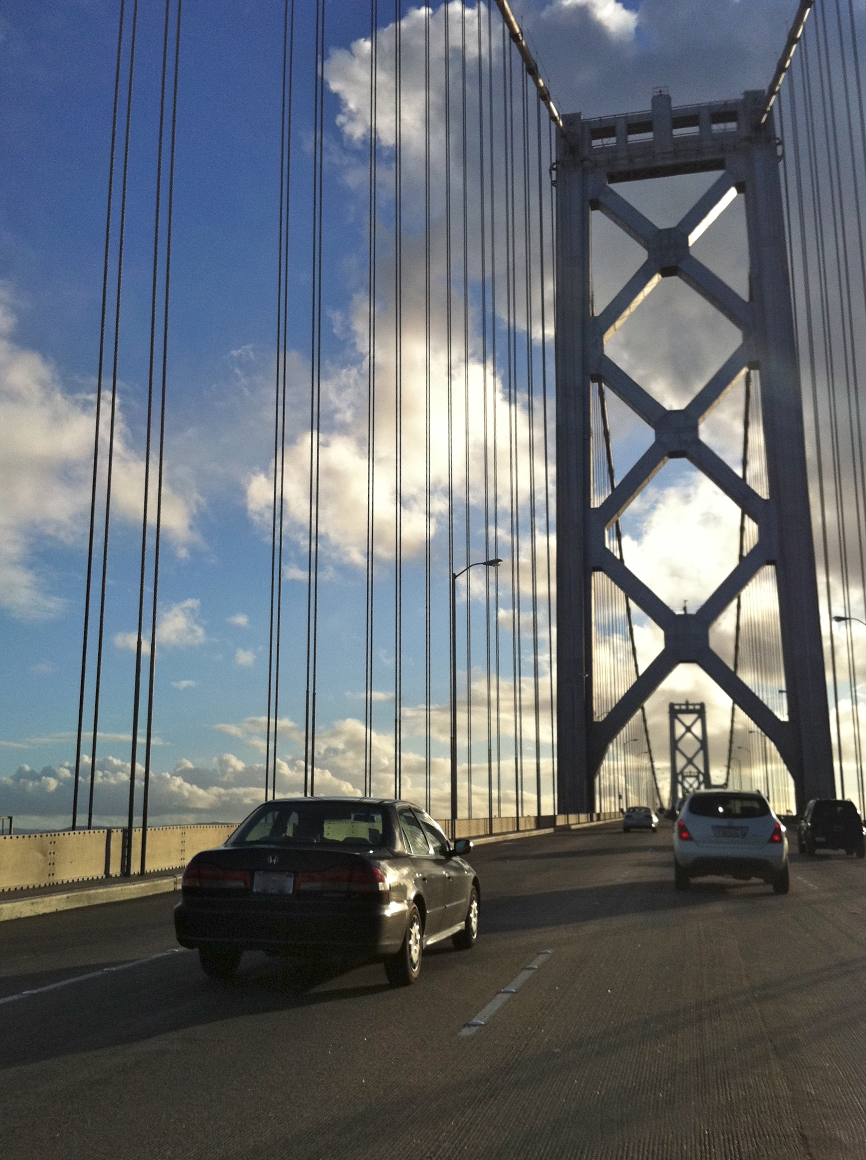
Rumor has it that they are doing new construction on the eastern span and when complete, it will be a much more attractive suspension bridge like the western span.

But given the pace of the Department of Transportation and CalTrans, I wonder if I’ll see it in my lifetime.


All photographs taken with an iPhone4 by Karen Fayeth and subject to the creative commons license as seen in the far right column of this page.


Walking On The Moon

Last weekend, toward the end of my visit to New Mexico, my best friend and I decided we needed to go somewhere without much in the way of civilization.

A break from the every day is good for the soul.

This year my friend had drawn out a tag to hunt Oryx, and about a month ago, she and her husband went out to the empty land around Upham, New Mexico as Oryx are plentiful there.

While she didn’t manage to get an Oryx this year, while hiking around, she witnessed a vista so amazing that she wanted to share it with me.

So we loaded up and went bouncing down dirt roads, me riding in the passenger seat. My job was to open and close gates so that we could make our way past ranches without much in the way of fences to contain their hungry cattle.

Since the truck we rode in sounds a lot like a feed truck, they’d come a galloping along to greet us. It was kind of hard to let down all of our bovine friends as we only had a fried chicken picnic to eat, and that’s not really cow food.

The land we saw as we bumped along was empty, otherworldly and beautiful.

My New Mexico readers will also know a bit about Upham as that is where the New Mexico Spaceport is being built with taxpayers money.

By taking publicly accessible roads, we were able to get pretty gosh darn close to the construction site.

Here’s what it looks like (click photo for larger size):


The Spaceport website has quite a few construction photos as well. I was struck by the fantastically long tarmac, pure concrete rumored to be almost two miles long and three feet deep. How the heck they got that much water out there to create that much cement is absolutely beyond me.

The actual location of the Spaceport is quite a ways off the highway, almost an hour in the truck, and it’s a good thing my friend was familiar with the area. I would have been quite lost.

After ooh’ing and aah’ing along with cussing and discussing the merits (or lack of) of the spaceport, we headed up a long and somewhat winding trail to get to a certain spot my friend had in mind.

That’s when the ooh’ing and aah’ing really began.

This photo does no justice to the almost 180 degree sweeping view from Anthony to Truth or Consequences. It was absolutely breathtaking.

Other than the guy who lives in the small ranch at the top of the rise, and some Oryx hunters, I don’t imagine a lot of people have gotten the chance to see this amazing view.

It made me proud to be a New Mexican. This is who I am. This is where I come from.


(click for larger size)


All photographs by Karen Fayeth and subject to the creative commons license as seen in the far right column of this page.


An Unheralded Medium for Communication

During my recent visit to New Mexico, I got the chance to appreciate a good ol’ fashioned medium for blasting one’s special kind of crazy out to the world.

Look, I’m not talking about no Twitter, no kind of Facebook, no blog telling the world how I think about things. No!

I’m talking about full on signs attached to one’s vehicular mode of transportation.

Not bumper stickers. Signs.

Who knew?

My trip began with a journey from the airport on I-10 headed for Las Cruces. For a large part of the journey, I followed an eighteen wheeler with a rather large sign attached to the back.

As a matter of fact, this sign:


Photo source


I mean, I don’t know for sure, but I always thought The Big Guy had a better sense of humor than that. I’d like to think if he had a problem with my little nickname, well, he’d just tell me. Why’d I have to learn about this from the back of a semi?

Should I call the number on the sign and ask?

Later that same day, I stopped off for lunch. I had a quick bite at a place over by the mall in Las Cruces and when I came out to my rental car, I noted that the car parked next to me was covered with stickers, signs and slogans.

The one that caught my eye was a bright yellow number that said:

“What if Glenn Beck is Right?”

After I finished hurting my head pondering what that meant, I was reminded of the South Park episode where Cartman riffs on Glenn Beck.

Which makes me wonder if maybe the real question is…what if Cartman is right?

Huh? Huh?

“I’m just asking questions!”

So seeing those two signs got me thinking about Southern New Mexico. It seems things have taken a lean to the right since I lived there last.

But just like the old saying about my home state, “If you don’t like the weather, wait ten minutes” turns out it took only a couple days to bring things back into perspective.

As I drove back to the airport on Sunday, again on I-10, I followed a beat up old Subaru with a hand-lettered sign on the back.

This bit of typesetting said, and I quote: “If you are going to ride my ass, the least you can do is pull my hair.”

In big letters. Covering the entire rear window.

Which just made my eyes ping-zing around in my brain while the word “Tilt” flashed over my head….

Cruces is getting to be an odd place.


I Will Find My Way

The Velcro on my Rand McNally road atlas had been rendered useless. Tan carpet fuzz from the back of the Jeep embedded itself irrevocably into the hook side of the mechanism.

The map was considered a “just in case” for getting lost, which happens often. The atlas was purchased well before there was something called a Google to provide maps on something called the internet.

That road atlas was aspirational. I bought it hoping that maybe I could travel a lot of those blue lined roads over the course of my life.

But suddenly the road atlas had meaning. It was more than a “just in case,” it was an essential tool.

The page for New Mexico was well worn, but the page for California was starting to show the dirt and grease of eager fingers tracing a path over and over again. A reduced scale journey west to my new home.

The compass rose became my bouquet, a present from the universe, welcoming me to my new life.

At a holiday cocktail party, the map became obsolete. A friend and professional truck driver wrote directions on the back of an envelope. “This is the faster way to go, you’ll shave several miles off the trip,” he told me.

He’d personally traveled those roads. Roads that were visible to me only as lines on a page in my mind.

He was the first of many milestones on my journey.

The tattered envelope with scrawled black pen, “I-40 west to Barstow” wasn’t anywhere near as magical as the pages produced by Rand McNally, but it was more useful, more functional. I clung to that envelope because my life really did depend upon it.

And then, finally, it was time.

May 1997, just a few days before Memorial Day, I climbed up behind the wheel of my Jeep while my best friend strapped into the passenger seat and took possession of both the envelope and the Rand McNally.

I-40 was a road I knew. Straight. West. No worries. Grants passed by quickly. Then before we knew it, there was Gallup.

Then the Arizona border.

My tires made a noise as they passed over, and I cried. I didn’t just cross this border casually. It meant something. It was a new frontier.

The entire State of Arizona lay ahead. Since Arizona was familiar, it eased me in. We settled into the miles while listening to Tom Jones and George Strait. We listened to everything I had in that Jeep and then tried to find decent radio stations.

Six hours. That’s how long it takes to traverse the State of Arizona.

Then my tires made another small sound and another border was crossed.

I was in California. I didn’t cry this time. Simply renewed my resolve and kept driving.

That was thirteen years ago, but it could be yesterday for how fresh it remains in my mind.

May I never lose my resolve. May I never lose my desire. May I never lose my ability to read a good old fashioned road map.

All it takes is a map, a little guidance from someone who bothers to care, and a step in the right direction and you can find your way.

If only someone could draw a map to help me navigate the more difficult emotional roads in my life. Those are uncharted.

I am both mapmaker and traveler and the journey never ends.

But the compass rose is still just as beautiful.

Photograph by Karin Lindstrom and used royalty free from stock.xchng

This week’s Theme Thursday is map.

Ow! *Slap*

And here we are at Friday, the end of another week.

An unusual week on my part, but happy to see Friday nonetheless.

Much to process from my day yesterday seeing old friends, burying a dear friend and reminiscing.

But for today, I’m here to talk about a feature of our Fair New Mexico that I really, really don’t miss.

Mosquitos.

Now, where I live, I’m sure such creatures exist. It’s just that I’ve not seen ’em.

I’m ok with not seeing them. Pinche insects.

I arrived Wednesday evening at my friend’s home out in the boonies north of Las Cruces, and noticed water standing in all the pecan groves and cotton fields.

“I see everyone is irrigating,” I mention.

Nope, they tell me. Rain. Three inches arrived the day before I did.

Which leaves standing water.

Perfect habitat for *slap* mosquitos.

I sat for maybe eight minutes outside at a table with a citronella candle on it. My arms. Fine. My ankles? Ten bites on the left, eight on the right.

Mosquitos in the house, too!

As I slept, I got zapped on the earlobe. The earlobe! The one place I forgot to apply repellent.

Gah!

And I won’t mention a spot rather close to an unmentionable place where I was also ruthlessly attacked. Twice!

Hate ’em. Always hated them. Sure, I grew up with bug bites up and down my legs, and it was a fact of life. But living without them sure has been pretty durn nice.

I don’t miss them. At all.

I’m not usually a fan of chemicals in the air, but even I cheered when the neighbors called the city to have the spraying truck come out. It helped, but didn’t eliminate all the little buggars.

*scratch* This Benedryl lotion I’m using isn’t helping one bit.

In other, happier, news I’ve been experimenting with night photography because the light noise at my friend’s place is minimal. You can see the ding dang milky way out here!

If I get anything decent, I’ll gladly share the results here.

As for now, onward to the weekend.